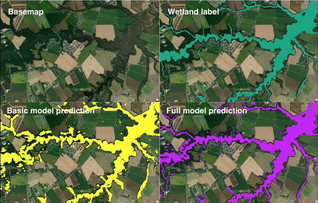
Keeping the environment healthy is the goal of this group of researchers and their new algorithm. This map of a wetlands area near the Chesapeake Bay demonstrates how AI can more accurately extrapolate and map data. (Source: Science of the Total Environment Journal)
AI Program Helps Researchers Find, Preserve Wetlands with 94% Accuracy
What do mapping wetlands and AI have to do with each other? Quite a lot actually. Most people don’t think about wetlands, unless they are researchers or housing developers looking for new places to build homes. It is vital to know the kind of ground you are building on. A website called directionsmag.com has a piece on how AI has not only corrected wetland data records but has found areas that can be returned to wetlands.
Chesapeake Conservancy’s data science team developed an AI deep learning model for mapping wetlands, which resulted in 94% accuracy. Supported by EPRI, an independent, non-profit energy research and development institute; Lincoln Electric System; and the Grayce B. Kerr Fund, Inc., this method for wetland mapping could deliver important outcomes for protecting and conserving wetlands. The results are published in the peer-reviewed journal Science of the Total Environment.
The team trained a machine learning (convolutional neural network) model for high-resolution (1m) wetland mapping with data from three areas: Mille Lacs County, Minnesota; Kent County, Delaware; and St. Lawrence County, New York. The full model, which requires local training data provided by state wetlands data and the National Wetlands Inventory (NWI), mapped wetlands with 94% accuracy.
“We’re happy to support this exciting project as it explores new methods for wetlands delineation using satellite imagery,” said EPRI Principal Technical Leader Dr. Nalini Rao. “It has the potential to save natural resource managers time in the field by using a GIS tool right from their desks. Plus, it can help companies and the public manage impacts to wetlands as infrastructure builds are planned to meet decarbonization targets.”
The new model will help planners avoid wetlands, saving money and helping to conserve wetlands. It may also contribute to efforts to develop renewable energy, which requires expanding electric power infrastructure.

The algorithm has updated the long inaccurate information around the Chesapeake Bay and a few other wetland areas.
The product of the model is a map of wetland probability. This probability data may be used to map the most likely wetland extent, but if users prefer, they can map the wetland extent with a lower probability threshold. The resulting map limits the likelihood of wetland omission even though it maps more wetlands than are present in reality.
Because local governments had outdated information on wetlands, it was allowing precious areas to be developed with little to no thought for the environment. This algorithm will go a long way toward providing accurate geographical information before more is ruined by developments.
The team will expand the model to states or larger regions and continue to train the model on varied geographies. Once again, AI adds value to a profession and improves results.
read more at directionsmag.com


Leave A Comment