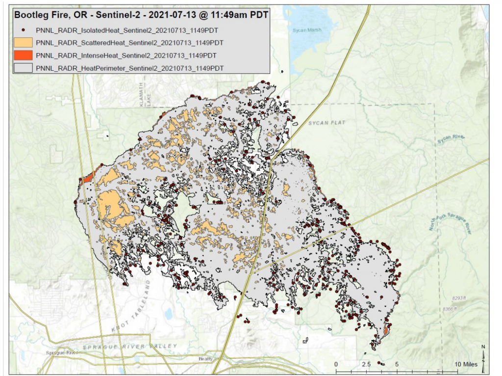
Image of the Bootleg Fire in Oregon was generated with a new mapping tool from Pacific Northwest National Laboratory. (Source: PNNL)
RADRFIRE Sharpens Images Downloaded from Satellite Fire-Watchers
From Washington to Montana or Arizona, the American West’s wildfires are becoming the lead on the national news almost nightly in the summer of 2021. Which was a worse fire season than 2020. Which was worse than 2019. You get the point. Each year the fires are wider, hotter, and harder to put out.
Currently, the fires are not just affecting the states they are burning in, but the smoke is being carried pretty much across the U.S. all the way to cities on the East Coast.
The battle to predict the nature of fires each year uses many different tools, and now it will be including the amazing RADRFIRE. The program is a highly touted and extremely well-supported tool that uses infrared satellite imagery and artificial intelligence to create detailed wildfire maps to track and forecast fires. Developed at the Pacific Northwest National Laboratory (PNNL) in Eastern Washington, in consultation with numerous agencies responsible for battling the fires, it was created in less than a year.
Geekwire.com published a Q & A with the project manager Andre Coleman.
“We’re seeing much larger fires these days. They’re a lot more dynamic, faster moving. We can’t always use the traditional methods that we’ve used,” said RADRFIRE project lead Andre Coleman. “We need to up the game a little bit.”
And by upping the game, Coleman uses a new algorithm that shrinks the pixel width from satellite images down from 2 kilometers to 30 meters. Which makes a huge improvement on spotting small fires more clearly from space and being more specific in sending resources.
Working with the Forest Service, the team has developed an algorithm to better plan and monitor the use of fire retardants that are dropped on blazes by aircraft.
RADRFIRE Is Accessible
Lisa Stiffler conducted a great interview with Colemen and covered a lot of ground regarding the how, what, and whys this program has such great promise. But who gets to use it may surprise you. Stiffler asked:
Whose satellites are these? Who owns the system?
The tool uses information from open-access domestic and international government satellites. The team worried that using commercial satellites would quickly become too costly and limit who could use the tool.
“We just feel like this should be open-access information,” Coleman said. “Somebody shouldn’t have to purchase it.”
Because the team is piggybacking on others’ satellites, they take what images they can get so some areas are photographed more or less than others and at random times. The project’s goal is to capture a couple of images a day, which is added to information gathered through other means to create a more complete picture.
Coleman expects that the program will continue to be managed by a government agency. The U.S. Department of Energy’s Artificial Intelligence Technology Office has supported it in collaboration with the U.S. Department of Defense’s Joint Artificial Intelligence Center. As mentioned above, this program is well supported.
The article goes deep into how it works and Coleman answers a lot of questions in depth. He paints a picture of a tool using AI, that might be the biggest asset in fighting fires to come along in a generation. It offers AI assistance before, during, and after a wildfire.
read more at geekwire.com


Leave A Comment