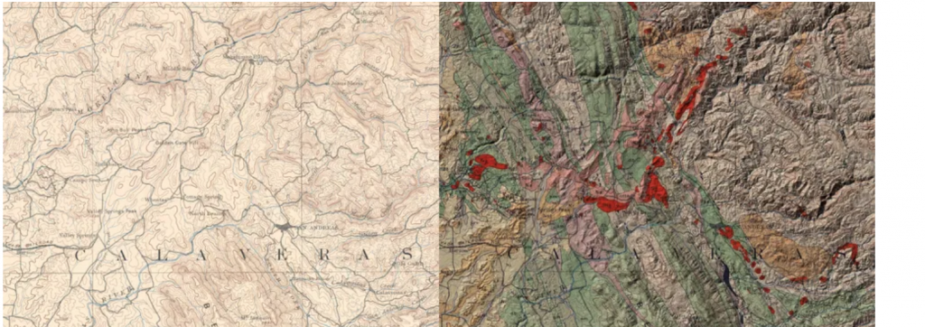
A before-and-after image of an economic geology map of Jackson Peak, California from 1894, which has been digitized. (Source: USGS/DARPA)
U.S. Agencies Use AI to Identify, Map & Build Mineral Supply Chain
If the United States is ever going to make the change from fossil fuels to green energy, it will require more mining within the country. Currently, minerals needed for the production of EV batteries are imported, which is expensive. Plus, having to rely on other nations for these rare minerals leaves the U.S. extremely vulnerable to international pressures. The answer of course is to find minerals within the country, so the Defense Department and the U.S Geological Survey are sending out a challenge to AI innovators.
Lisa Martine Jenkins has written for protocal.com about these critical minerals and how AI might be used to find, map, and lead the search for these 50 minerals within the confines of America.
The end goal of the challenges is not to automate the assessments entirely, said Graham Lederer, a research geologist at USGS’ Geology, Energy and Minerals Science Center. Rather, it is to come up with a way to use AI to accelerate the process of digitizing long-buried maps and other data and use them to understand the landscape of the country’s mineral resources.
“Right now, we do this basically one commodity at a time or one mineral deposit type at a time, because it’s so manual and it takes a lot of human effort,” Lederer said. “But if you set up the machine learning algorithms well and generalize the solutions well, [we] could be doing all 50 commodities simultaneously, which would be transformative in how we work and the pace at which we work.”
While the government’s geologists and its military technology researchers may seem like strange bedfellows, the collaboration could allow the former to speed up the geological assessments that are the first step in building out a domestic critical supply chain. Given the national security implications as well as the need to deploy clean energy technology as quickly as possible, that mission has added urgency.
“Part of the problem is that we collected so much data 70, 80, 90 years ago, before digital data collection was possible and effective,” said Joshua Elliott, a program manager working on information innovation at DARPA, DOD’s research arm. “We’re kind of behind because we were so far ahead. So much of our data is actually locked in these incredibly valuable and incredibly detailed maps that were produced by [USGS experts] two generations ago.”
Part of the challenge is to digitize the vast stockpile of maps the U.S Geological Survey already has. Once put into the right media, the hope is our satellites will have a clearer picture of where to dig. That will require someone to produce the next generation of geological information related to mining with AI.
There are essentially two steps — corresponding to the two challenges — that are required to use the existing maps to locate minerals. The first is, Elliott said, “extreme precision georeferencing” to digitize hard copies and scans of maps into a usable format. Then, researchers need to extract important features like fault lines and geological formations to figure out where mineral deposits might sit. By hand, this would be a painstakingly long process, but Elliott said AI and machine learning have the potential to “make a substantial dent in” the time it could take.
But time is of the essence. The Energy Act of 2020 set a goal of completing all critical mineral assessments in four years. That’s how long it can take the USGS to assess the availability of a single mineral.
read more at protocol.com


Leave A Comment